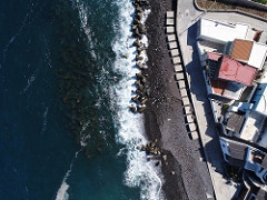
Aerial photogrammetric surveys at Lipari island pilot site.
Meetings and Events
Thursday, 21 September 2017 00:00
On 21 September 2017, aerofotogrammetry flights were carried out in the pilot site of Lipari.
In particular, the beaches of Acquacalda, Canneto and Baia Portinenti have been detected with a drones that has safely flipped over these areas.
High-resolution images have been captured to allow coastal flooding scenarios caused by rising sea levels as a result of ongoing climate change and land subsidence.
We are thankful to the people of Lipari for their enthusiastic support.
Address
Lipari, 98050 Lipari ME
Italia
Italia
Map
All Dates
- Thursday, 21 September 2017 00:00